Geolocate

Ciwaringin topographic map

Click on the map to display elevation.

About this map

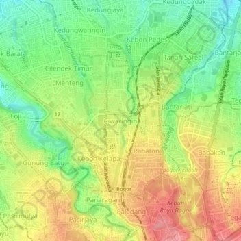
Name: Ciwaringin topographic map, elevation, terrain.

Location: Ciwaringin, Bogor, West Java, Java, 16192, Indonesia (-6.60408 106.77018 -6.56408 106.81018)

Average elevation: 231 m

Minimum elevation: 185 m

Maximum elevation: 281 m

Other topographic maps

Click on a map to view its topography, its elevation and its terrain.

Bogor Selatan

Indonesia > West Java > Bogor

Average elevation: 377 m

Bogor Timur

Indonesia > West Java > Bogor

Average elevation: 329 m

Tanah Sareal

Indonesia > West Java > Bogor

Average elevation: 182 m

Tanah Sareal

Indonesia > West Java > Bogor

Average elevation: 215 m

Bogor Barat

Indonesia > West Java > Bogor

Average elevation: 215 m

Ciomas

Indonesia > West Java > Bogor

Average elevation: 230 m

Gear up for your next adventure:

🕯️Camping Lantern - Illuminates your entire campsite with high-efficiency LEDs
💡LED Headlamp - Hands-free illumination for night hiking and camping
🔦LED Headlamp - Hands-free lighting for early morning starts or late finishes
🪑Insulated Seat Pad - Protect your seat from cold rocks and wet logs
👟Leg Gaiters - Keep debris, mud, and snow out of your boots

As an Amazon Associate, this site earns from qualifying purchases at no extra cost to you.