
Fern Park topographic map
Interactive map
Click on the map to display elevation.
About this map
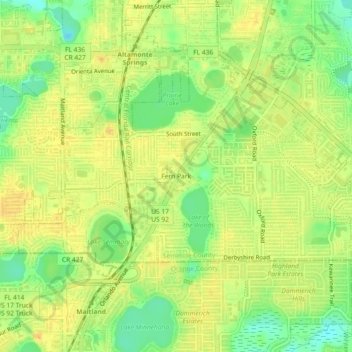
Name: Fern Park topographic map, elevation, terrain.
Location: Fern Park, Seminole County, Florida, 32730, United States (28.62916 -81.37118 28.66916 -81.33118)
Average elevation: 30 m
Minimum elevation: 12 m
Maximum elevation: 39 m
Other topographic maps
Click on a map to view its topography, its elevation and its terrain.
Lake Monroe
United States > Florida > Seminole County
Lake Monroe, Seminole County, Florida, 32747, United States
Average elevation: 8 m
Oviedo
United States > Florida > Seminole County
Oviedo, Seminole County, Florida, United States
Average elevation: 14 m
Geneva
United States > Florida > Seminole County > Geneva
Geneva, Seminole County, Florida, 32732, United States
Average elevation: 11 m
Sanford
United States > Florida > Seminole County
Sanford, Seminole County, Florida, United States
Average elevation: 8 m
St. Johns River
United States > Florida > Seminole County
St. Johns River, Seminole County, Florida, United States
Average elevation: 14 m