Geolocate

Tiwu topographic map

Click on the map to display elevation.

About this map

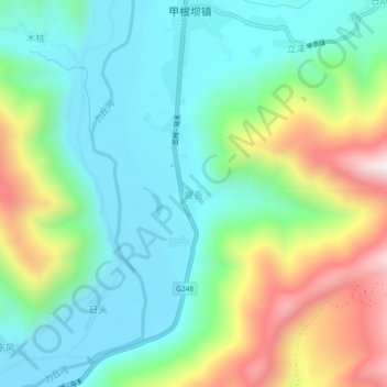
Name: Tiwu topographic map, elevation, terrain.

Location: Tiwu, Kangding, Kardze, Sichuan, 626000, China (29.80750 101.53746 29.84750 101.57746)

Average elevation: 3,557 m

Minimum elevation: 3,326 m

Maximum elevation: 4,084 m

Other topographic maps

Click on a map to view its topography, its elevation and its terrain.

贡巴冰川

China > Sichuan > Kangding

Average elevation: 5,375 m

康定跑马山风景区

China > Sichuan > Kangding > Jingangsi

Average elevation: 2,804 m

Gear up for your next adventure:

🥾Trail Hiking Boots - Supportive boots for rough trails
🥾Hiking Shoes - Durable and comfortable shoes for trail hiking
🧣Merino Neck Gaiter - Protects against wind, sun, and cold at high altitudes
🦯Trekking Poles - Reduced impact on joints for steep topographic climbs
🔦LED Headlamp - Hands-free lighting for early morning starts or late finishes

As an Amazon Associate, this site earns from qualifying purchases at no extra cost to you.