Geolocate

Halmstad topographic map

Click on the map to display elevation.

About this map

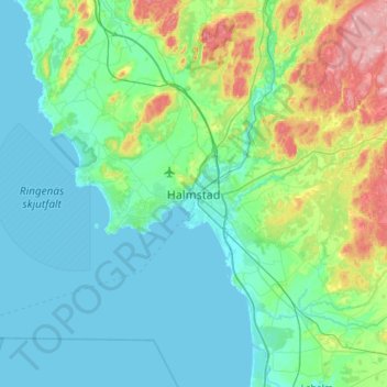
Name: Halmstad topographic map, elevation, terrain.

Location: Halmstad, Halmstads kommun, Halland County, 302 42, Sweden (56.51398 12.69748 56.83398 13.01748)

Average elevation: 38 m

Minimum elevation: -2 m

Maximum elevation: 206 m

Gear up for your next adventure:

🧦Crew Hiking Socks - Comfortable socks for long-distance hikes
🧦Thermal Socks - Warm socks for winter hiking or camping
👟Sport Hiking Sandals - Breathable footwear for water crossings and camp rest
🥾Durable Hiking Shoes - Long-lasting shoes for frequent hiking
🏃Hydration Running Vest - Carry water and maps close to your body for speed

As an Amazon Associate, this site earns from qualifying purchases at no extra cost to you.