Geolocate

Kemangkon topographic map

Click on the map to display elevation.

About this map

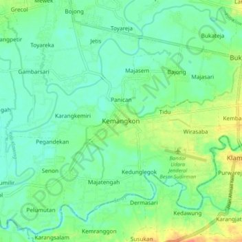
Name: Kemangkon topographic map, elevation, terrain.

Location: Kemangkon, Purbalingga, Central Java, Java, 53382, Indonesia (-7.48980 109.35261 -7.40980 109.43261)

Average elevation: 37 m

Minimum elevation: 20 m

Maximum elevation: 74 m

Other topographic maps

Click on a map to view its topography, its elevation and its terrain.

RT 04 RW 1

Indonesia > Central Java > Purbalingga > RT 04 RW 1

Average elevation: 1,213 m

Gear up for your next adventure:

🦟Insect Repellent - Keep mosquitoes and black flies away in wooded areas
🔋Solar Power Bank - Keep your GPS and devices charged during long outdoor trips
🥾Mountain Hiking Shoes - Shoes with superior grip for mountainous terrain
🥾Mountain Trail Shoes - High-traction shoes for mountain trails
💧Filtered Water Bottle - Safe drinking water on the go

As an Amazon Associate, this site earns from qualifying purchases at no extra cost to you.