
Make a donation
Gear up for your next adventure:
As an Amazon Associate, this site earns from qualifying purchases at no extra cost to you.
Tintigny topographic map
Click on the map to display elevation.
Make a donation
Gear up for your next adventure:
As an Amazon Associate, this site earns from qualifying purchases at no extra cost to you.
About this map
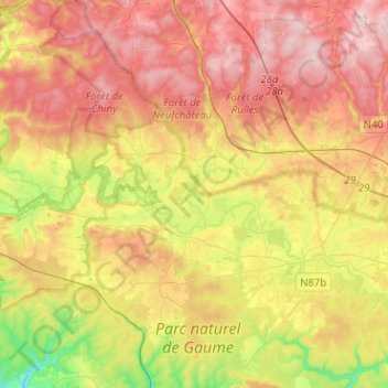
Name: Tintigny topographic map, elevation, terrain.
Location: Tintigny, Virton, Luxemburg, Wallonië, België (49.61936 5.41654 49.78336 5.55666)
Average elevation: 366 m
Minimum elevation: 233 m
Maximum elevation: 479 m
Make a donation
Gear up for your next adventure:
As an Amazon Associate, this site earns from qualifying purchases at no extra cost to you.
Other topographic maps
Click on a map to view its topography, its elevation and its terrain.
Make a donation
Gear up for your next adventure:
As an Amazon Associate, this site earns from qualifying purchases at no extra cost to you.
Montquintin
Het dorp ligt op een heuvel van 330 meter hoogte en kijkt uit over de omgeving van Virton, het dal van de Ton, en de cellulosefabriek van Harnoncourt.
Average elevation: 244 m
Make a donation
Gear up for your next adventure:
As an Amazon Associate, this site earns from qualifying purchases at no extra cost to you.
Torgny
Torgny ligt in de Gaumestreek/Belgisch-Lotharingen. Het riviertje de Chiers vormt ter hoogte van Torgny over een aantal kilometer de landsgrens. Het dorpje is gelegen op een zuidelijk gerichte helling, op de flanken van de vallei van de Chiers. Dit geeft, samen met de beperkte hoogteligging (275 m) en de…
Average elevation: 242 m
Make a donation
Gear up for your next adventure:
As an Amazon Associate, this site earns from qualifying purchases at no extra cost to you.
Make a donation
Gear up for your next adventure:
As an Amazon Associate, this site earns from qualifying purchases at no extra cost to you.