Geolocate

Vercelli topographic map

Click on the map to display elevation.

About this map

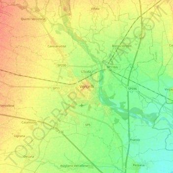
Name: Vercelli topographic map, elevation, terrain.

Location: Vercelli, Piedmont, Italy (45.27773 8.31617 45.37234 8.51368)

Average elevation: 130 m

Minimum elevation: 110 m

Maximum elevation: 150 m

Other topographic maps

Click on a map to view its topography, its elevation and its terrain.

Foresto

Italy > Piedmont > Vercelli > Borgosesia

Average elevation: 647 m

Sn2

Italy > Piedmont > Vercelli > Boccioleto

Average elevation: 1,290 m

Ruse

Italy > Piedmont > Vercelli > Varallo > I Prati

Average elevation: 787 m

Fontana dello Zolfo

Italy > Piedmont > Vercelli > Trino

Average elevation: 149 m

Le Castelle

Italy > Piedmont > Vercelli > Gattinara

Average elevation: 314 m

San Giuseppe

Italy > Piedmont > Vercelli

Average elevation: 1,618 m

Sasso Lungo

Italy > Piedmont > Vercelli > Scopa > Otra

Average elevation: 854 m

Montata

Italy > Piedmont > Vercelli > Varallo

Average elevation: 1,217 m

Gear up for your next adventure:

💡LED Headlamp - Hands-free illumination for night hiking and camping
🧼Biodegradable Camp Soap - Environmentally friendly cleaning for gear and body
🧢Sun Hat - Wide-brim hat for sun protection
👟Trail Running Shoes - Agile footwear for fast-paced topographic exploration
💡Compact LED Flashlight - Powerful and portable flashlight for outdoor use

As an Amazon Associate, this site earns from qualifying purchases at no extra cost to you.