Geolocate

Sharpes topographic map

Click on the map to display elevation.

About this map

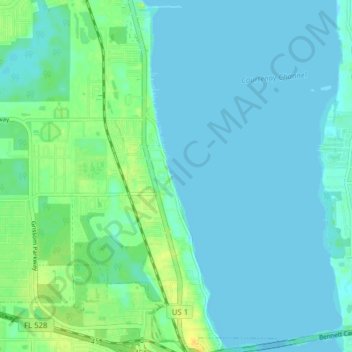
Name: Sharpes topographic map, elevation, terrain.

Location: Sharpes, Cocoa, Brevard County, Florida, United States (28.40147 -80.77513 28.47004 -80.73527)

Average elevation: 5 m

Minimum elevation: -1 m

Maximum elevation: 22 m

Gear up for your next adventure:

🧥Softshell Hiking Jacket - The perfect balance of wind protection and breathability
🥾Trekking Boots - Durable boots for long-distance trekking
👟Trail Running Shoes - Agile footwear for fast-paced topographic exploration
🧥Waterproof Hiking Jacket - Protect yourself from rain and wind while hiking
🧴Waterproofing Spray - Restore the DWR coating on jackets and tents

As an Amazon Associate, this site earns from qualifying purchases at no extra cost to you.