Geolocate

Kronach topographic map

Click on the map to display elevation.

About this map

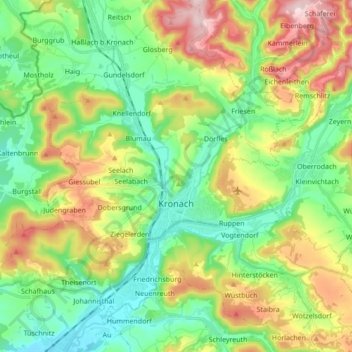
Name: Kronach topographic map, elevation, terrain.

Location: Kronach, Landkreis Kronach, Bavaria, 96317, Germany (50.19341 11.26470 50.30324 11.41768)

Average elevation: 394 m

Minimum elevation: 287 m

Maximum elevation: 587 m

Gear up for your next adventure:

👟Trail Running Shoes - Agile footwear for fast-paced topographic exploration
🧥Fleece Jacket - Warm and lightweight jacket for layering
🧥Softshell Jacket - Windproof and breathable jacket for hiking
🥘Camping Cookware Set - Compact nesting pots and pans for trail cooking
💧Filtered Water Bottle - Safe drinking water on the go

As an Amazon Associate, this site earns from qualifying purchases at no extra cost to you.