Geolocate

Troina topographic map

Click on the map to display elevation.

About this map

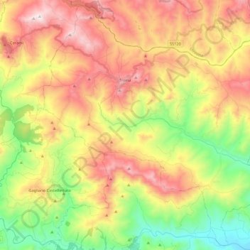
Name: Troina topographic map, elevation, terrain.

Location: Troina, Enna, Sicily, 94018, Italy (37.67276 14.52996 37.83651 14.74467)

Average elevation: 712 m

Minimum elevation: 247 m

Maximum elevation: 1,231 m

Gear up for your next adventure:

🧥Thermal Fleece Jacket - Versatile insulation for changing mountain temperatures
Backpacking Tent - Lightweight tent for long-distance hiking trips
🕯️Camping Lantern - Illuminates your entire campsite with high-efficiency LEDs
🧊Portable Cooler - Keep food and drinks cold during outdoor adventures
🥾Trail Running Boots - Durable shoes designed for trail running

As an Amazon Associate, this site earns from qualifying purchases at no extra cost to you.