Geolocate

Shobdon topographic map

Click on the map to display elevation.

About this map

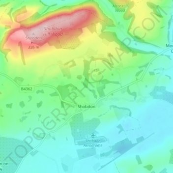
Name: Shobdon topographic map, elevation, terrain.

Location: Shobdon, Herefordshire, England, United Kingdom (52.23693 -2.91504 52.27711 -2.83786)

Average elevation: 151 m

Minimum elevation: 84 m

Maximum elevation: 325 m

Other topographic maps

Click on a map to view its topography, its elevation and its terrain.

Merryhill

United Kingdom > England > Herefordshire > Brinsop

Average elevation: 139 m

Gear up for your next adventure:

🧭GPS Tracker - Track your location in remote areas safely
🥘Camping Cookware Set - Compact nesting pots and pans for trail cooking
🧢Hiking Sun Hat - Wide-brimmed protection for exposed mountain ridges
🥾Trail Running Boots - Durable shoes designed for trail running
🥾Trail Hiking Shoes - Durable shoes designed for rugged trails

As an Amazon Associate, this site earns from qualifying purchases at no extra cost to you.