
Make a donation
Gear up for your next adventure:
As an Amazon Associate, this site earns from qualifying purchases at no extra cost to you.
Datu Paglas topographic map
Click on the map to display elevation.
Make a donation
Gear up for your next adventure:
As an Amazon Associate, this site earns from qualifying purchases at no extra cost to you.
About this map
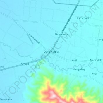
Name: Datu Paglas topographic map, elevation, terrain.
Average elevation: 57 m
Minimum elevation: 11 m
Maximum elevation: 509 m
Make a donation
Gear up for your next adventure:
As an Amazon Associate, this site earns from qualifying purchases at no extra cost to you.
Other topographic maps
Click on a map to view its topography, its elevation and its terrain.
Liguasan Marsh
Philippines > Maguindanao del Sur > General Salipada K. Pendatun
Average elevation: 9 m
Make a donation
Gear up for your next adventure:
As an Amazon Associate, this site earns from qualifying purchases at no extra cost to you.
Lake Buluan
Philippines > Maguindanao del Sur > Mangudadatu
Lake Buluan is a lake located in the island of Mindanao in the Philippines. With an estimated surface area of 61.34 square kilometres (23.68 sq mi), it is the third largest lake in Mindanao, after Lake Lanao and Lake Mainit. It has an average elevation of 4.5 metres (15 ft).
Average elevation: 48 m
Make a donation
Gear up for your next adventure:
As an Amazon Associate, this site earns from qualifying purchases at no extra cost to you.