
Thank you for supporting this site ❤️
Make a donation
Make a donation
Gear up for your next adventure:
As an Amazon Associate, this site earns from qualifying purchases at no extra cost to you.
Tête du Fer à Cheval topographic map
Click on the map to display elevation.
Thank you for supporting this site ❤️
Make a donation
Make a donation
Gear up for your next adventure:
As an Amazon Associate, this site earns from qualifying purchases at no extra cost to you.
About this map
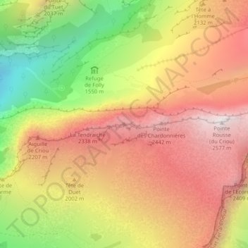
Name: Tête du Fer à Cheval topographic map, elevation, terrain.
Average elevation: 1,903 m
Minimum elevation: 1,030 m
Maximum elevation: 2,571 m
Thank you for supporting this site ❤️
Make a donation
Make a donation
Gear up for your next adventure:
As an Amazon Associate, this site earns from qualifying purchases at no extra cost to you.
Other topographic maps
Click on a map to view its topography, its elevation and its terrain.
Lac de Gers
France > Auvergne-Rhône-Alpes > Haute-Savoie > Samoëns > Chalets de Gers
Le lac de Gers est un lac situé sur la commune de Samoëns, en Haute-Savoie, qui culmine à 1 537 m d'altitude.
Average elevation: 1,762 m