
Make a donation
Gear up for your next adventure:
As an Amazon Associate, this site earns from qualifying purchases at no extra cost to you.
El Guanaco topographic map
Click on the map to display elevation.
Make a donation
Gear up for your next adventure:
As an Amazon Associate, this site earns from qualifying purchases at no extra cost to you.
About this map
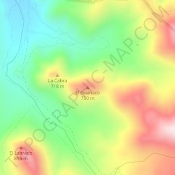
Name: El Guanaco topographic map, elevation, terrain.
Average elevation: 617 m
Minimum elevation: 403 m
Maximum elevation: 902 m
Make a donation
Gear up for your next adventure:
As an Amazon Associate, this site earns from qualifying purchases at no extra cost to you.
Other topographic maps
Click on a map to view its topography, its elevation and its terrain.
Parque Nacional La Campana
Chile > Región de Valparaíso > Provincia de Quillota > Hijuelas
En La Campana existen muchas especies de lagartos, lagartijas y culebras. Por las mañanas es más fácil observarlos, puesto que siendo estos animales ectotermos, se encontrarán a esta hora menos activos, tomando sol para regular su temperatura. Hay registro de las siguientes especies, distribuidas en el…
Average elevation: 938 m