Geolocate

Yautepec topographic map

Click on the map to display elevation.

About this map

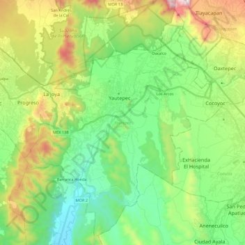
Name: Yautepec topographic map, elevation, terrain.

Location: Yautepec, Morelos, Mexico (18.77098 -99.14838 18.95972 -98.93299)

Average elevation: 1,335 m

Minimum elevation: 964 m

Maximum elevation: 2,121 m

Gear up for your next adventure:

🏕️Camping Hammock - Integrated protection for sleeping between trees
🥾Hiking Leggings - Comfortable leggings for outdoor activities
🛁Quick-Dry Microfiber Towel - Space-saving towel that dries rapidly on the move
🥫Freeze-Dried Meals - Lightweight, high-calorie nutrition for multi-day treks
💧Reusable Water Bottle - Durable water bottles for hydration on trails

As an Amazon Associate, this site earns from qualifying purchases at no extra cost to you.