
Make a donation
Gear up for your next adventure:
As an Amazon Associate, this site earns from qualifying purchases at no extra cost to you.
Tlaxco topographic map
Click on the map to display elevation.
Make a donation
Gear up for your next adventure:
As an Amazon Associate, this site earns from qualifying purchases at no extra cost to you.
Tlaxco
Situated in the Mexican Altiplano, Tlaxco lies at an average altitude of 2,540 metres (8,330 ft) above sea level. The western and central parts of the municipality are relatively flat, while the northern and eastern parts of the municipality feature more rugged terrain. The highest point in the municipality is the Cerro Peñas Coloradas located at 19°39′55″N 98°03′11″W / 19.6653°N 98.0531°W / 19.6653; -98.0531 with an elevation of 3,360 metres (11,020 ft) above sea level. The Zahuapan River and its tributaries drain the central-eastern part of the municipality. There are also two reservoirs in the municipality, Lázaro Cárdenas in the extreme east and El Muerto in the west. Agricultural land comprises 65.43% of the municipality. Soils in the municipality include cambisols, fluvisols, lithosols, gleysols and andosols.
Make a donation
Gear up for your next adventure:
As an Amazon Associate, this site earns from qualifying purchases at no extra cost to you.
About this map
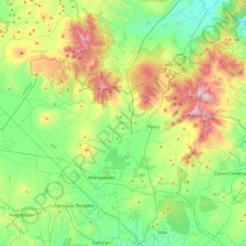
Name: Tlaxco topographic map, elevation, terrain.
Location: Tlaxco, Tlaxcala, 90251, Mexico (19.51089 -98.38170 19.72892 -97.95375)
Average elevation: 2,650 m
Minimum elevation: 2,273 m
Maximum elevation: 3,476 m
Make a donation
Gear up for your next adventure:
As an Amazon Associate, this site earns from qualifying purchases at no extra cost to you.
Other topographic maps
Click on a map to view its topography, its elevation and its terrain.
Tlaxcala City
Mexico > Tlaxcala > Municipio de Tlaxcala
The city is located in the central Mexican highlands 2,239 metres (7,346 feet) above sea level, in a valley of the same name, from which the Popocatépetl and Iztaccíhuatl volcanoes can be seen in the distance. The main elevations in the municipality are El Cerro Ostol at 2,460 metres (8,070 feet) and El…
Average elevation: 2,414 m
Make a donation
Gear up for your next adventure:
As an Amazon Associate, this site earns from qualifying purchases at no extra cost to you.
Huamantla
The municipality is located in the eastern half of the state of Tlaxcala, in the Central Mexican Highlands. It has an average altitude of 2,500 meters above sea level. The geography of the municipality has three types of relief. About twenty percent is rugged mountain (located in the far north and far south),…
Average elevation: 2,519 m