Geolocate

Palanpur topographic map

Click on the map to display elevation.

Palanpur

Palanpur is located at 24°06′N 72°15′E / 24.10°N 72.25°E / 24.10; 72.25. It has an average elevation of 209 metres (685 ft).

About this map

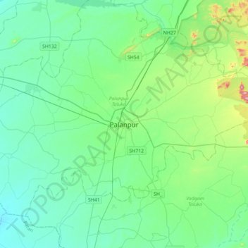
Name: Palanpur topographic map, elevation, terrain.

Location: Palanpur, Palanpur Taluka, Banas Kantha District, Gujarat, 385001, India (24.01098 72.27664 24.33098 72.59664)

Average elevation: 204 m

Minimum elevation: 121 m

Maximum elevation: 578 m

Gear up for your next adventure:

🎒Hiking Backpack - Lightweight and ergonomic backpacks for day hikes or multi-day treks
🥾Trekking Poles - Adjustable trekking poles to reduce knee stress and improve stability
🥾Waterproof Trail Shoes - Shoes designed to handle wet terrain
🧦Merino Wool Socks - Moisture-wicking comfort for long-distance hiking
💧Hydration Bladder - Hands-free hydration solution for long treks

As an Amazon Associate, this site earns from qualifying purchases at no extra cost to you.