
Make a donation
Gear up for your next adventure:
As an Amazon Associate, this site earns from qualifying purchases at no extra cost to you.
Les Gèrats topographic map
Click on the map to display elevation.
Make a donation
Gear up for your next adventure:
As an Amazon Associate, this site earns from qualifying purchases at no extra cost to you.
About this map
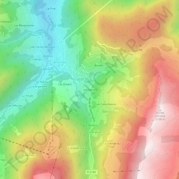
Name: Les Gèrats topographic map, elevation, terrain.
Average elevation: 1,496 m
Minimum elevation: 951 m
Maximum elevation: 2,100 m
Make a donation
Gear up for your next adventure:
As an Amazon Associate, this site earns from qualifying purchases at no extra cost to you.
Other topographic maps
Click on a map to view its topography, its elevation and its terrain.
Arêches
France > Auvergne-Rhône-Alpes > Savoie > Beaufort
Il est situé entre 1 025 et 2 281 m. Un télésiège 4-places débrayable construit en 1983 - soit l'un des premiers de ce type en France - part directement depuis le village, et rejoint Le Cuvy (1 710 m). La seule piste noire du sous-domaine est située sous la ligne de montée. Selon le niveau d'enneigement…
Average elevation: 1,235 m
Make a donation
Gear up for your next adventure:
As an Amazon Associate, this site earns from qualifying purchases at no extra cost to you.