Geolocate

Reus topographic map

Click on the map to display elevation.

Reus

Se encuentra a una altitud entre 94 y 142 metros sobre el nivel del mar y dista unos 14 km de la capital, Tarragona.

About this map

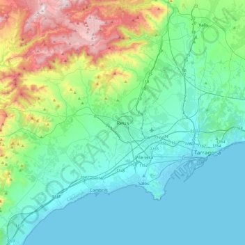
Name: Reus topographic map, elevation, terrain.

Location: Reus, Bajo Campo, Tarragona, Cataluña, 43201, España (40.99556 0.94761 41.31556 1.26761)

Average elevation: 239 m

Minimum elevation: -3 m

Maximum elevation: 1,131 m

Gear up for your next adventure:

🧥Softshell Hiking Jacket - The perfect balance of wind protection and breathability
🛌Down Sleeping Bag - Superior warmth-to-weight ratio for cold nights
🌡️Emergency Mylar Blankets - Compact thermal protection for unexpected nights outdoors
🥾Trail Running Boots - Durable shoes designed for trail running
🧭GPS Tracker - Track your location in remote areas safely

As an Amazon Associate, this site earns from qualifying purchases at no extra cost to you.