Geolocate

Merlera topographic map

Click on the map to display elevation.

About this map

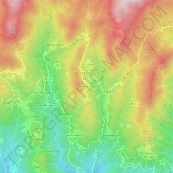
Name: Merlera topographic map, elevation, terrain.

Location: Merlera, Cellio con Breia, Vercelli, Piemonte, 13024, Italia (45.74155 8.31177 45.78155 8.35177)

Average elevation: 761 m

Minimum elevation: 484 m

Maximum elevation: 1,062 m

Gear up for your next adventure:

🧢Outdoor Visor - Breathable visor for sunny hikes
🧢Beanie Hat - Keep your head warm in cold weather
🥾Trail Hiking Shoes - Durable shoes designed for rugged trails
🧦Outdoor Socks - Durable socks designed for hiking and outdoor sports
🧊Portable Cooler - Keep food and drinks cold during outdoor adventures

As an Amazon Associate, this site earns from qualifying purchases at no extra cost to you.