
Make a donation
Gear up for your next adventure:
As an Amazon Associate, this site earns from qualifying purchases at no extra cost to you.
Caltanissetta topographic map
Click on the map to display elevation.
Make a donation
Gear up for your next adventure:
As an Amazon Associate, this site earns from qualifying purchases at no extra cost to you.
Caltanissetta
The expansive territory of Caltanissetta ranks as Italy's 14th largest comune by area and the fourth largest in Sicily, following Noto, Monreale, and Ragusa. Located in Sicily's interior, it has no coastline. The terrain, part of the Erean Mountains, is predominantly hilly, with its highest peak reaching 859 meters (2,818 feet) above sea level. The city center, at an elevation of 568 meters (1,864 feet), makes Caltanissetta the seventh-highest provincial capital in Italy, surpassed in Sicily only by Enna.
Make a donation
Gear up for your next adventure:
As an Amazon Associate, this site earns from qualifying purchases at no extra cost to you.
About this map
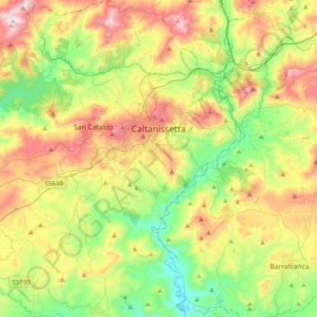
Name: Caltanissetta topographic map, elevation, terrain.
Location: Caltanissetta, Sicily, 93100, Italy (37.32953 13.86153 37.59852 14.15556)
Average elevation: 429 m
Minimum elevation: 160 m
Maximum elevation: 847 m
Make a donation
Gear up for your next adventure:
As an Amazon Associate, this site earns from qualifying purchases at no extra cost to you.
Other topographic maps
Click on a map to view its topography, its elevation and its terrain.