Geolocate

Copen topographic map

Click on the map to display elevation.

About this map

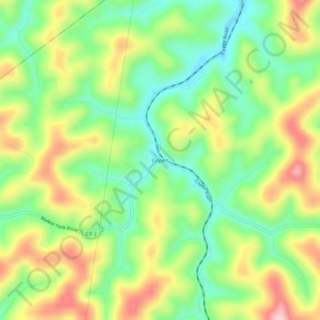
Name: Copen topographic map, elevation, terrain.

Location: Copen, Braxton County, West Virginia, 26615, United States (38.81760 -80.74954 38.85760 -80.70954)

Average elevation: 334 m

Minimum elevation: 240 m

Maximum elevation: 463 m

Other topographic maps

Click on a map to view its topography, its elevation and its terrain.

Flatwoods

United States > West Virginia > Braxton County

Average elevation: 364 m

Sutton

United States > West Virginia > Braxton County

Average elevation: 320 m

Gear up for your next adventure:

💧Hydration Bladder - Hands-free hydration solution for long treks
🕯️Camping Lantern - Illuminates your entire campsite with high-efficiency LEDs
🧦Crew Hiking Socks - Comfortable socks for long-distance hikes
🧴Sunscreen SPF - Broad-spectrum sunscreen for outdoor activities
🛏️Camping Sleeping Mat - Comfortable mats for sleeping outdoors

As an Amazon Associate, this site earns from qualifying purchases at no extra cost to you.