Geolocate

Sharpsburg topographic map

Click on the map to display elevation.

About this map

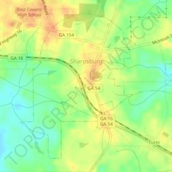
Name: Sharpsburg topographic map, elevation, terrain.

Location: Sharpsburg, Coweta County, Georgia, United States (33.32400 -84.66096 33.34675 -84.63958)

Average elevation: 273 m

Minimum elevation: 252 m

Maximum elevation: 292 m

Other topographic maps

Click on a map to view its topography, its elevation and its terrain.

East Newnan

United States > Georgia > Coweta County

Average elevation: 290 m

Arnco Mills

United States > Georgia > Coweta County

Average elevation: 256 m

McBride

United States > Georgia > Coweta County > Newnan

Average elevation: 280 m

McCollum

United States > Georgia > Coweta County

Average elevation: 284 m

Gear up for your next adventure:

Camping Coffee Maker - Brew fresh coffee anywhere on the topographic map
🥾Hiking Shorts - Breathable shorts suitable for summer hikes
🧴First Aid Kit - Essential first aid supplies for outdoor emergencies
Lightweight Camping Tent - Portable shelter optimized for Canadian backcountry camping
🥾Trekking Boots - Durable boots for long-distance trekking

As an Amazon Associate, this site earns from qualifying purchases at no extra cost to you.