
Thank you for supporting this site ❤️
Make a donation
Make a donation
Gear up for your next adventure:
As an Amazon Associate, this site earns from qualifying purchases at no extra cost to you.
Oskaloosa topographic map
Click on the map to display elevation.
Thank you for supporting this site ❤️
Make a donation
Make a donation
Gear up for your next adventure:
As an Amazon Associate, this site earns from qualifying purchases at no extra cost to you.
About this map
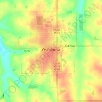
Name: Oskaloosa topographic map, elevation, terrain.
Location: Oskaloosa, Jefferson County, Kansas, United States (39.20512 -95.32384 39.22426 -95.30397)
Average elevation: 329 m
Minimum elevation: 298 m
Maximum elevation: 349 m
Thank you for supporting this site ❤️
Make a donation
Make a donation
Gear up for your next adventure:
As an Amazon Associate, this site earns from qualifying purchases at no extra cost to you.
Other topographic maps
Click on a map to view its topography, its elevation and its terrain.
Valley Falls
United States > Kansas > Jefferson County > Valley Falls > Valley Falls
Average elevation: 296 m