
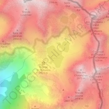
Lac de Rabuons topographic map
Interactive map
Click on the map to display elevation.
About this map
Name: Lac de Rabuons topographic map, elevation, terrain.
Average elevation: 2,607 m
Minimum elevation: 1,809 m
Maximum elevation: 3,015 m
Other topographic maps
Click on a map to view its topography, its elevation and its terrain.
Lac de Rabuons
France > Provence-Alpes-Côte d'Azur > Saint-Étienne-de-Tinée
Lac de Rabuons, Les Balcons du Mercantour, Saint-Étienne-de-Tinée, Nice, Alpes-Maritimes, Provence-Alpes-Côte d'Azur, France métropolitaine, 06660, France
Average elevation: 2,650 m
Mont Riounet
France > Provence-Alpes-Côte d'Azur > Saint-Étienne-de-Tinée
Mont Riounet, Saint-Étienne-de-Tinée, Nice, Alpes-Maritimes, Provence-Alpes-Côte d'Azur, France métropolitaine, 06660, France
Average elevation: 2,175 m
Plan d'eau des Trinitaires
France > Provence-Alpes-Côte d'Azur > Saint-Étienne-de-Tinée
Plan d'eau des Trinitaires, Sentier de l'Eau, Saint-Étienne-de-Tinée, Nice, Alpes-Maritimes, Provence-Alpes-Côte d'Azur, France métropolitaine, 06660, France
Average elevation: 1,441 m
Lacs de Vens
France > Provence-Alpes-Côte d'Azur > Saint-Étienne-de-Tinée
Lacs de Vens, Chemin de l'Énergie, Saint-Étienne-de-Tinée, Nice, Alpes-Maritimes, Provence-Alpes-Côte d'Azur, France métropolitaine, 06660, France
Average elevation: 2,385 m
Lacs Morgons
France > Provence-Alpes-Côte d'Azur > Saint-Étienne-de-Tinée
Lacs Morgons, M 64, Saint-Étienne-de-Tinée, Nice, Alpes-Maritimes, Provence-Alpes-Côte d'Azur, France métropolitaine, 06660, France
Average elevation: 2,392 m