
Make a donation
Gear up for your next adventure:
As an Amazon Associate, this site earns from qualifying purchases at no extra cost to you.
Fernwood topographic map
Click on the map to display elevation.
Make a donation
Gear up for your next adventure:
As an Amazon Associate, this site earns from qualifying purchases at no extra cost to you.
About this map
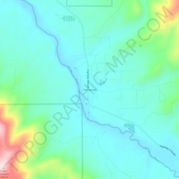
Name: Fernwood topographic map, elevation, terrain.
Location: Fernwood, Benewah County, Idaho, 83830, United States (47.09213 -116.41266 47.13213 -116.37266)
Average elevation: 882 m
Minimum elevation: 810 m
Maximum elevation: 1,161 m
Make a donation
Gear up for your next adventure:
As an Amazon Associate, this site earns from qualifying purchases at no extra cost to you.
Other topographic maps
Click on a map to view its topography, its elevation and its terrain.
Tensed
United States > Idaho > Benewah County
Tensed is located at 47°9′37″N 116°55′27″W / 47.16028°N 116.92417°W / 47.16028; -116.92417 (47.160284, -116.924304), at an elevation of 2,562 feet (781 m) above sea level.
Average elevation: 785 m