
Make a donation
Gear up for your next adventure:
As an Amazon Associate, this site earns from qualifying purchases at no extra cost to you.
La Libertad topographic map
Click on the map to display elevation.
Make a donation
Gear up for your next adventure:
As an Amazon Associate, this site earns from qualifying purchases at no extra cost to you.
La Libertad
La Libertad es una ciudad ecuatoriana; cabecera cantonal del cantón La Libertad, así como la urbe más poblada de la Provincia de Santa Elena. Se localiza al centro-sur de la región litoral del Ecuador, en la puntilla de Santa Elena, que es el extremo occidental del Ecuador continental, a una altitud de 10 ms.n.m. y con un clima árido cálido de 24,7 °C en promedio.
Make a donation
Gear up for your next adventure:
As an Amazon Associate, this site earns from qualifying purchases at no extra cost to you.
About this map
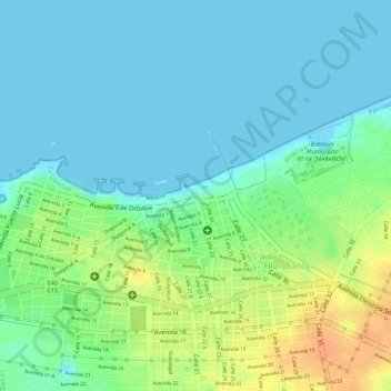
Name: La Libertad topographic map, elevation, terrain.
Average elevation: 13 m
Minimum elevation: -1 m
Maximum elevation: 39 m
Make a donation
Gear up for your next adventure:
As an Amazon Associate, this site earns from qualifying purchases at no extra cost to you.