
Thank you for supporting this site ❤️
Make a donation
Make a donation
Gear up for your next adventure:
As an Amazon Associate, this site earns from qualifying purchases at no extra cost to you.
Shaglli topographic map
Click on the map to display elevation.
Thank you for supporting this site ❤️
Make a donation
Make a donation
Gear up for your next adventure:
As an Amazon Associate, this site earns from qualifying purchases at no extra cost to you.
About this map
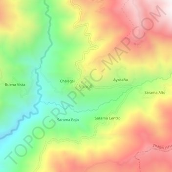
Name: Shaglli topographic map, elevation, terrain.
Location: Shaglli, Zhaglli (Shaglli), Santa Isabel, Azuay, Ecuador (-3.19200 -79.40654 -3.15200 -79.36654)
Average elevation: 2,802 m
Minimum elevation: 2,294 m
Maximum elevation: 3,355 m
Thank you for supporting this site ❤️
Make a donation
Make a donation
Gear up for your next adventure:
As an Amazon Associate, this site earns from qualifying purchases at no extra cost to you.
Other topographic maps
Click on a map to view its topography, its elevation and its terrain.