Geolocate

Lamas topographic map

Click on the map to display elevation.

About this map

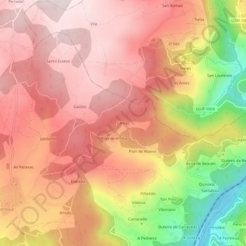
Name: Lamas topographic map, elevation, terrain.

Location: Lamas, Celaguantes, A Peroxa, Ourense, Galicia, 32449, Spain (42.43379 -7.78912 42.47379 -7.74912)

Average elevation: 480 m

Minimum elevation: 107 m

Maximum elevation: 684 m

Other topographic maps

Click on a map to view its topography, its elevation and its terrain.

O Souto

Spain > Galicia > Ourense > A Peroxa

Average elevation: 574 m

Gear up for your next adventure:

🧥Softshell Hiking Jacket - The perfect balance of wind protection and breathability
🥾Mountain Trail Shoes - High-traction shoes for mountain trails
🥽Outdoor Goggles - Protective eyewear for outdoor activities
🧭GPS Outdoor Watch - Smart watch for navigation and fitness tracking in nature
🧶550 Survival Paracord - Versatile utility cord for emergency repairs and rigging

As an Amazon Associate, this site earns from qualifying purchases at no extra cost to you.