Geolocate

Massenberg topographic map

Click on the map to display elevation.

About this map

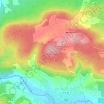
Name: Massenberg topographic map, elevation, terrain.

Location: Massenberg, Spalt, Landkreis Roth, Bayern, 91174, Deutschland (49.19140 10.92055 49.19150 10.92065)

Average elevation: 435 m

Minimum elevation: 360 m

Maximum elevation: 509 m

Gear up for your next adventure:

Camping Essentials - All-in-one gear for a comfortable camping trip
🛶Canoe Life Vest - Safety vest for water sports
🔦LED Headtorch - Bright and durable light for night activities
🚲Handlebar Phone Mount - View topographic-map.com live while cycling
🎒Hiking Backpack - Lightweight and ergonomic backpacks for day hikes or multi-day treks

As an Amazon Associate, this site earns from qualifying purchases at no extra cost to you.