
Alberto Maia topographic map
Click on the map to display elevation.
About this map
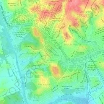
Name: Alberto Maia topographic map, elevation, terrain.
Average elevation: 49 m
Minimum elevation: 13 m
Maximum elevation: 102 m
Other topographic maps
Click on a map to view its topography, its elevation and its terrain.
Camaragibe
Brasil > Pernambuco > Região Metropolitana do Recife > Camaragibe
Localiza-se a uma latitude 08º01'18" sul e a uma longitude 34º58'52" oeste, estando a uma altitude de 55 metros.
Average elevation: 58 m
Vale Das Pedreiras
Brasil > Pernambuco > Região Metropolitana do Recife > Camaragibe
Average elevation: 50 m
Alto Santo Antônio
Brasil > Pernambuco > Região Metropolitana do Recife > Camaragibe
Average elevation: 50 m