Geolocate

Kenova topographic map

Click on the map to display elevation.

About this map

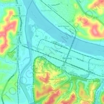
Name: Kenova topographic map, elevation, terrain.

Location: Kenova, Wayne County, West Virginia, United States (38.38149 -82.59702 38.42186 -82.56525)

Average elevation: 186 m

Minimum elevation: 155 m

Maximum elevation: 265 m

Other topographic maps

Click on a map to view its topography, its elevation and its terrain.

Brabant

United States > West Virginia > Wayne County

Average elevation: 291 m

Lavalette

United States > West Virginia > Wayne County

Average elevation: 213 m

Crum

United States > West Virginia > Wayne County

Average elevation: 249 m

Gear up for your next adventure:

🦯Trekking Poles - Reduced impact on joints for steep topographic climbs
🥾Trail Running Boots - Durable shoes designed for trail running
💧Hydration Bladder - Hands-free hydration solution for long treks
🥾Hiking Shoes - Durable and comfortable shoes for trail hiking
🧢Outdoor Visor - Breathable visor for sunny hikes

As an Amazon Associate, this site earns from qualifying purchases at no extra cost to you.