Geolocate

Ulignano topographic map

Click on the map to display elevation.

About this map

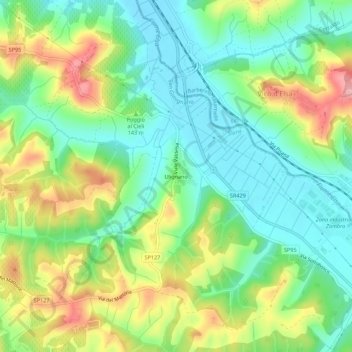
Name: Ulignano topographic map, elevation, terrain.

Location: Ulignano, San Gimignano, Siena, Tuscany, 50052, Italy (43.48385 11.06138 43.52385 11.10138)

Average elevation: 125 m

Minimum elevation: 72 m

Maximum elevation: 215 m

Gear up for your next adventure:

🧢Sun Protection Cap - Breathable cap to protect from sun exposure
🥾Lightweight Hiking Boots - Boots for comfort and mobility on long hikes
🧶550 Survival Paracord - Versatile utility cord for emergency repairs and rigging
🩹Compact First Aid Kit - Pre-packed essentials for common trail injuries
🪑Ultralight Camping Stool - Compact seating for rest stops during long hikes

As an Amazon Associate, this site earns from qualifying purchases at no extra cost to you.