Geolocate

Lac des Journalistes topographic map

Click on the map to display elevation.

About this map
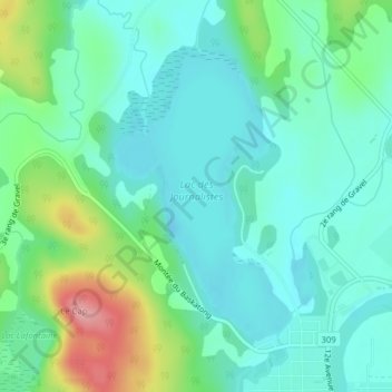
Name: Lac des Journalistes topographic map, elevation, terrain.

Location: Lac des Journalistes, Ferme-Neuve, Antoine-Labelle, Laurentides, Québec, Canada (46.70590 -75.47159 46.72582 -75.45359)

Average elevation: 234 m

Minimum elevation: 203 m

Maximum elevation: 324 m

Other topographic maps

Click on a map to view its topography, its elevation and its terrain.
Lac des Iles

Canada > Québec > Antoine-Labelle > Ferme-Neuve

Average elevation: 393 m

Mont Sir-Wilfrid

Canada > Québec > Antoine-Labelle > Ferme-Neuve

Average elevation: 605 m

Gear up for your next adventure:

🥾Hiking Shoes - Durable and comfortable shoes for trail hiking
🛶Canoe Life Vest - Safety vest for water sports
💡LED Headlamp - Hands-free illumination for night hiking and camping
🧳Compression Sacks - Maximize space in your backpack by shrinking gear
🌬️Windproof Camp Stove - Efficient cooking even on exposed mountain peaks

As an Amazon Associate, this site earns from qualifying purchases at no extra cost to you.