
Make a donation
Gear up for your next adventure:
As an Amazon Associate, this site earns from qualifying purchases at no extra cost to you.
South Highland topographic map
Click on the map to display elevation.
Make a donation
Gear up for your next adventure:
As an Amazon Associate, this site earns from qualifying purchases at no extra cost to you.
About this map
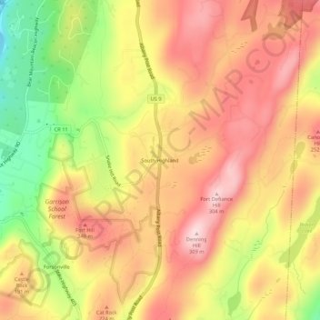
Name: South Highland topographic map, elevation, terrain.
Average elevation: 178 m
Minimum elevation: -3 m
Maximum elevation: 300 m
Make a donation
Gear up for your next adventure:
As an Amazon Associate, this site earns from qualifying purchases at no extra cost to you.
Other topographic maps
Click on a map to view its topography, its elevation and its terrain.
Kent Cliffs Unit
United States > New York > Putnam County > Town of Putnam Valley > Richardsville
Average elevation: 270 m
Make a donation
Gear up for your next adventure:
As an Amazon Associate, this site earns from qualifying purchases at no extra cost to you.
Michael Ciaiola Conservation Area
United States > New York > Putnam County > Town of Patterson > Putnam Lake
Average elevation: 294 m