
Plavecké Podhradie topographic map
Interactive map
Click on the map to display elevation.
About this map
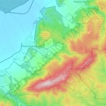
Name: Plavecké Podhradie topographic map, elevation, terrain.
Average elevation: 365 m
Minimum elevation: 184 m
Maximum elevation: 715 m
Other topographic maps
Click on a map to view its topography, its elevation and its terrain.
Malacky
Slovakia > Region of Bratislava > District of Malacky
Malacky, District of Malacky, Region of Bratislava, Slovakia
Average elevation: 169 m