
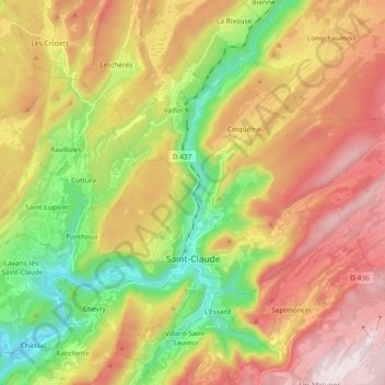
Saint-Claude topographic map
Interactive map
Click on the map to display elevation.
About this map
Name: Saint-Claude topographic map, elevation, terrain.
Average elevation: 814 m
Minimum elevation: 350 m
Maximum elevation: 1,323 m
Other topographic maps
Click on a map to view its topography, its elevation and its terrain.
Montain
France > Bourgogne-Franche-Comté > Jura
Montain, Lons-le-Saunier, Jura, Bourgogne-Franche-Comté, Metropolitan France, 39210, France
Average elevation: 316 m
Marnoz
France > Bourgogne-Franche-Comté > Jura
Marnoz, Dole, Jura, Bourgogne-Franche-Comté, Metropolitan France, 39110, France
Average elevation: 377 m
Rye
France > Bourgogne-Franche-Comté > Jura
Rye, Lons-le-Saunier, Jura, Bourgogne-Franche-Comté, Metropolitan France, 39230, France
Average elevation: 203 m
Salins-les-Bains
France > Bourgogne-Franche-Comté > Jura
Salins-les-Bains, Dole, Jura, Bourgogne-Franche-Comté, Metropolitan France, 39110, France
Average elevation: 512 m
Grande-Rivière
France > Bourgogne-Franche-Comté > Jura > Grande-Rivière-Château
Grande-Rivière, Grande-Rivière-Château, Saint-Claude, Jura, Bourgogne-Franche-Comté, Metropolitan France, 39150, France
Average elevation: 947 m