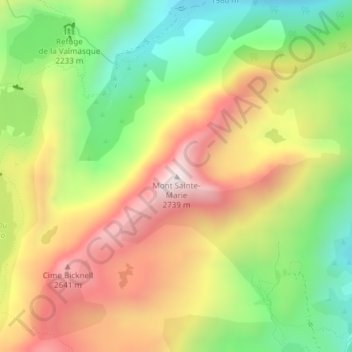
Mont Sainte-Marie topographic map
Interactive map
Click on the map to display elevation.
About this map
Name: Mont Sainte-Marie topographic map, elevation, terrain.
Average elevation: 2,324 m
Minimum elevation: 1,955 m
Maximum elevation: 2,720 m

Click on the map to display elevation.
Name: Mont Sainte-Marie topographic map, elevation, terrain.
Average elevation: 2,324 m
Minimum elevation: 1,955 m
Maximum elevation: 2,720 m