
Rottnest Island topographic map
Interactive map
Click on the map to display elevation.
About this map
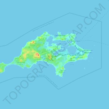
Name: Rottnest Island topographic map, elevation, terrain.
Location: Rottnest Island, Perth, Western Australia, 6161, Australia (-32.02684 115.44906 -31.98711 115.55932)
Average elevation: 2 m
Minimum elevation: -3 m
Maximum elevation: 45 m
Other topographic maps
Click on a map to view its topography, its elevation and its terrain.
Kings Park
Australia > Western Australia > Perth
Kings Park, Perth, City of Perth, Western Australia, Australia
Average elevation: 31 m
Caulfield Park
Australia > Western Australia > Perth
Caulfield Park, Willetton, Perth, Western Australia, Australia
Average elevation: 18 m