
Palm Springs topographic map
Interactive map
Click on the map to display elevation.
Palm Springs
One possible origin of palm in the place name comes from early Spanish explorers who referred to the area as La Palma de la Mano de Dios or "The Palm of God's hand". The earliest use of the name "Palm Springs" is from United States Topographical Engineers who used the term in 1853 maps. According to William Bright, when the word "palm" appears in Californian place names, it usually refers to the native California fan palm, Washingtonia filifera, which is abundant in the Palm Springs area. Other early names were "Palmetto Spring" and "Big Palm Springs".
About this map
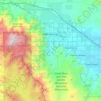
Name: Palm Springs topographic map, elevation, terrain.
Location: Palm Springs, Riverside County, California, United States (33.61242 -116.71209 33.93198 -116.44280)
Average elevation: 859 m
Minimum elevation: 41 m
Maximum elevation: 3,277 m
Other topographic maps
Click on a map to view its topography, its elevation and its terrain.
Colorado River
United States > California > Riverside County
The entire eastern boundary of the Colorado River Basin runs along the North American Continental Divide and is defined largely by the Rocky Mountains and the Rio Grande Basin. The Wind River Range in Wyoming marks the northern extent of the basin, and is separated from the Colorado Rockies by the endorheic…
Average elevation: 93 m
Coachella Valley
United States > California > Riverside County > Palm Desert
The area is surrounded on the southwest by the Santa Rosa Mountains, by the San Jacinto Mountains to the west, the Little San Bernardino Mountains to the east and San Gorgonio Mountain to the north. These mountains peak at around 11,000 feet (3,400 m) and tend to average between 5,000 and 7,000 feet (1,500 and…
Average elevation: 72 m
Idyllwild-Pine Cove
United States > California > Riverside County
"Mile-high Idyllwild" is a mountain resort about one-mile (1,600 m) in altitude. Idyllwild is flanked by two large rock formations, Tahquitz Peak and Suicide Rock (also known as Lily Rock), which are famous in Southern California rock-climbing circles. It offers no skiing, so "the Hill" has been minimally…
Average elevation: 1,746 m