
Bainbridge Island topographic map
Interactive map
Click on the map to display elevation.
About this map
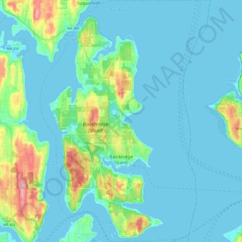
Name: Bainbridge Island topographic map, elevation, terrain.
Average elevation: 24 m
Minimum elevation: -5 m
Maximum elevation: 151 m
Other topographic maps
Click on a map to view its topography, its elevation and its terrain.
Carpenter Lake Nature Preserve
United States > Washington > Kitsap County > Kingston
Carpenter Lake Nature Preserve, Carpenter Lake Trail, Kingston, Kitsap County, Washington, 98346, United States
Average elevation: 36 m
Port Orchard
United States > Washington > Kitsap County
Port Orchard, Kitsap County, Washington, United States
Average elevation: 71 m
Silverdale
United States > Washington > Kitsap County
Silverdale, Kitsap County, Washington, 98383, United States
Average elevation: 68 m