
Clermont-Ferrand topographic map
Interactive map
Click on the map to display elevation.
Clermont-Ferrand
A racing circuit close to the city, the Charade Circuit, using closed-off public roads, held the French Grand Prix in 1965, 1969, 1970 and 1972. It was a daunting circuit, with such harsh elevation changes that some drivers became ill as they drove. Winners included Jim Clark, Jackie Stewart (twice), and Jochen Rindt.
About this map
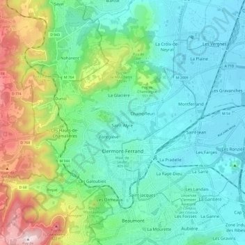
Name: Clermont-Ferrand topographic map, elevation, terrain.
Average elevation: 470 m
Minimum elevation: 326 m
Maximum elevation: 899 m
Other topographic maps
Click on a map to view its topography, its elevation and its terrain.