
Common Side topographic map
Interactive map
Click on the map to display elevation.
About this map
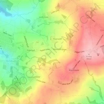
Name: Common Side topographic map, elevation, terrain.
Average elevation: 193 m
Minimum elevation: 108 m
Maximum elevation: 265 m
Other topographic maps
Click on a map to view its topography, its elevation and its terrain.
Castle Hill
United Kingdom > England > Kirklees > Farnley Tyas
Castle Hill, Castle Hill Side, Newsome, Farnley Tyas, Kirklees, West Yorkshire, England, HD4 6TA, United Kingdom
Average elevation: 168 m
Hall Ing
United Kingdom > England > Kirklees > Brockholes
Hall Ing, Holme Valley, Brockholes, Kirklees, West Yorkshire, England, HD9 6QX, United Kingdom
Average elevation: 184 m
Emley
United Kingdom > England > Kirklees
Emley, Kirklees, West Yorkshire, England, HD8 9RT, United Kingdom
Average elevation: 156 m
Windy Bank
United Kingdom > England > Kirklees > Windy Bank
Windy Bank, Kirklees, West Yorkshire, Yorkshire and the Humber, England, WF15 8LE, United Kingdom
Average elevation: 121 m