Geolocate

Northern Province topographic map

Interactive map

Click on the map to display elevation.

About this map

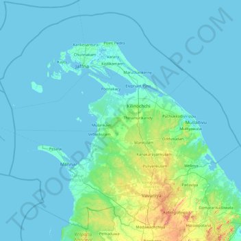
Name: Northern Province topographic map, elevation, terrain.

Location: Northern Province, Sri Lanka (8.52195 79.39592 10.03500 81.12709)

Average elevation: 18 m

Minimum elevation: -2 m

Maximum elevation: 391 m

Other topographic maps

Click on a map to view its topography, its elevation and its terrain.

Mullaitivu District

Sri Lanka > Northern Province

Mullaitivu District, Northern Province, Sri Lanka

Average elevation: 22 m

Mannar District

Sri Lanka > Northern Province

Mannar District, Northern Province, 41000, Sri Lanka

Average elevation: 21 m

Jaffna

Sri Lanka > Northern Province

Jaffna, Jaffna District, Northern Province, 40000, Sri Lanka

Average elevation: 3 m

Point Pedro

Sri Lanka > Northern Province > Point Pedro

Point Pedro, Jaffna District, Northern Province, 40600, Sri Lanka

Average elevation: 4 m

Vavuniya

Sri Lanka > Northern Province > Vavuniya

Vavuniya, Vavuniya District, Northern Province, 43000, Sri Lanka

Average elevation: 91 m