
Kullagh Lake topographic map
Interactive map
Click on the map to display elevation.
About this map
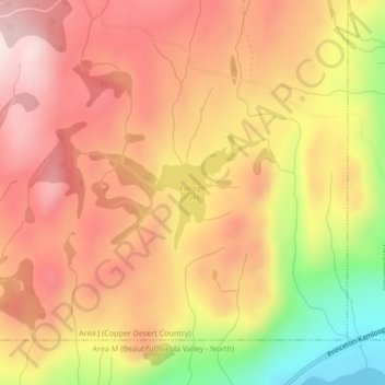
Name: Kullagh Lake topographic map, elevation, terrain.
Average elevation: 962 m
Minimum elevation: 743 m
Maximum elevation: 1,095 m
Other topographic maps
Click on a map to view its topography, its elevation and its terrain.
Paska Lake
Canada > British Columbia > Area J (Copper Desert Country)
Paska Lake, Area J (Copper Desert Country), Thompson-Nicola Regional District, British Columbia, Canada
Average elevation: 1,493 m
Walloper Lake
Canada > British Columbia > Area J (Copper Desert Country)
Walloper Lake, Area J (Copper Desert Country), Thompson-Nicola Regional District, British Columbia, Canada
Average elevation: 1,330 m