
Port Edward topographic map
Interactive map
Click on the map to display elevation.
About this map
Name: Port Edward topographic map, elevation, terrain.
Average elevation: 98 m
Minimum elevation: -1 m
Maximum elevation: 853 m
North Coast Regional District trails, hiking, mountain biking, running and outdoor activities
Other topographic maps
Click on a map to view its topography, its elevation and its terrain.
Sandspit
Canada > British Columbia > North Coast Regional District > Area E (Moresby Island)
Average elevation: 13 m
Coast Mountains
Canada > British Columbia > North Coast Regional District > Area A (North Skeena)
Average elevation: 334 m
Taaw Tldáaw
Canada > British Columbia > North Coast Regional District > Area D (Graham Island)
Average elevation: 8 m
Lax Kw'alaams
Canada > British Columbia > North Coast Regional District > Area A (North Skeena)
Average elevation: 63 m
Skeena
Canada > British Columbia > North Coast Regional District > Area A (North Skeena)
Average elevation: 61 m
Jalun Lake
Canada > British Columbia > North Coast Regional District > Area D (Graham Island)
Average elevation: 207 m
Queen Charlotte
Canada > British Columbia > North Coast Regional District > Queen Charlotte (Village) > Queen Charlotte
Average elevation: 113 m
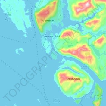
Watson Island
Canada > British Columbia > North Coast Regional District > Prince Rupert > Watson Island
Average elevation: 104 m