
Nita Lake topographic map
Interactive map
Click on the map to display elevation.
About this map
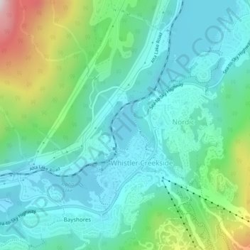
Name: Nita Lake topographic map, elevation, terrain.
Average elevation: 749 m
Minimum elevation: 626 m
Maximum elevation: 1,146 m
Other topographic maps
Click on a map to view its topography, its elevation and its terrain.
Whistler
Canada > British Columbia > Squamish-Lillooet Regional District > Whistler Resort Municipality > Whistler
Whistler, Whistler Resort Municipality, Squamish-Lillooet Regional District, British Columbia, 8E 0X5, Canada
Average elevation: 996 m