Geolocate

Mangrove Mountain topographic map

Interactive map

Click on the map to display elevation.

About this map

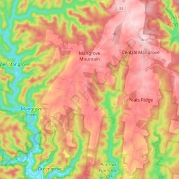
Name: Mangrove Mountain topographic map, elevation, terrain.

Location: Mangrove Mountain, Central Coast Council, New South Wales, 2250, Australia (-33.38734 151.14283 -33.26192 151.22487)

Average elevation: 194 m

Minimum elevation: -1 m

Maximum elevation: 352 m

Other topographic maps

Click on a map to view its topography, its elevation and its terrain.

Sydney

Australia > New South Wales

Phillip had been given no instructions for urban development, but in July 1788 submitted a plan for the new town at Sydney Cove. It included a wide central avenue, a permanent Government House, law courts, hospital and other public buildings, but no provision for warehouses, shops, or other commercial…

Average elevation: 53 m

Newcastle

Australia > New South Wales > Newcastle

Average elevation: 5 m

Sydney

Australia > New South Wales > Sydney

Average elevation: 23 m

Wollongong

Australia > New South Wales > Wollongong

Average elevation: 115 m

Orange

Australia > New South Wales

Orange is a city in the Central Tablelands region of New South Wales, Australia. It is 254 km (158 mi) west of the state capital, Sydney [206 km (128 mi) on a great circle], at an altitude of 862 metres (2,828 ft). Orange had an estimated urban population of 40,493 as of June 2018 making the city a significant…

Average elevation: 852 m

Windsor

Australia > New South Wales > Sydney

Average elevation: 12 m

Grafton

Australia > New South Wales

Average elevation: 36 m

Bowraville

Australia > New South Wales

Average elevation: 33 m

Taree

Australia > New South Wales

Average elevation: 17 m

Kempsey

Australia > New South Wales > Kempsey

Average elevation: 15 m

Gosford

Australia > New South Wales

Average elevation: 75 m

Maitland

Australia > New South Wales > Maitland

Average elevation: 16 m

Mudgee

Australia > New South Wales

Average elevation: 535 m

Round Hill

Australia > New South Wales > Nelson Bay

Average elevation: 36 m

Mount Kosciuszko

Australia > New South Wales

Mount Kosciuszko is the highest summit in mainland Australia. Until 1977 it was possible to drive from Charlotte Pass to within a few metres of the summit, but in 1977 the road was closed to public motor vehicle access due to environmental concerns. The road is open from Charlotte Pass for walkers and cyclists…

Average elevation: 2,035 m

Bowral

Australia > New South Wales

Average elevation: 690 m

Burrell Creek

Australia > New South Wales

Average elevation: 81 m

Bruinbun

Australia > New South Wales

Average elevation: 680 m

Northern Beaches

Australia > New South Wales > Sydney

Average elevation: 67 m

Hunter Valley

Australia > New South Wales > Cessnock

Average elevation: 70 m

Jindabyne

Australia > New South Wales > Jindabyne

Average elevation: 983 m

Manly

Australia > New South Wales > Sydney

Average elevation: 17 m

Cooma

Australia > New South Wales > Cooma

Average elevation: 860 m

Port Macquarie

Australia > New South Wales

Average elevation: 5 m

Penrith

Australia > New South Wales > Sydney > Penrith

Penrith is a city in New South Wales, Australia, located in Greater Western Sydney, 55 kilometres (31 mi) west of the Sydney central business district on the banks of the Nepean River, on the outskirts of the Cumberland Plain. Its elevation is 32 metres (105 ft).

Average elevation: 34 m

Lane Cove

Australia > New South Wales > Sydney

Average elevation: 52 m

Royal National Park

Australia > New South Wales

Average elevation: 123 m

Hawkesbury River

Australia > New South Wales > Sydney

Average elevation: 117 m

Illawarra

Australia > New South Wales

Average elevation: 234 m

Pitt Town

Australia > New South Wales > Sydney

Average elevation: 19 m

Riverstone

Australia > New South Wales > Sydney

Average elevation: 26 m

Byron Bay

Australia > New South Wales

Average elevation: 7 m

Goulburn

Australia > New South Wales

Owing to its elevation, Goulburn has an oceanic climate (Cfb) with warm summers and cool winters; with a high diurnal range. Its climate is variable much of the year, though generally dry with maximum temperatures ranging from 11.8 °C (53.2 °F) in July to 28.3 °C (82.9 °F) in January. Rainfall is…

Average elevation: 666 m

Katoomba

Australia > New South Wales > Sydney

Average elevation: 912 m

Mosman

Australia > New South Wales > Sydney

Average elevation: 28 m

Armidale

Australia > New South Wales

Average elevation: 1,036 m