
Bellshill topographic map
Interactive map
Click on the map to display elevation.
About this map
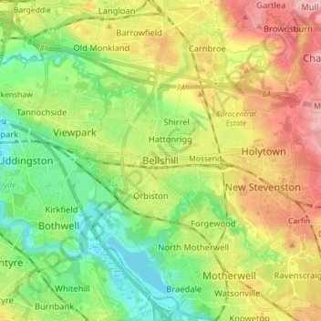
Name: Bellshill topographic map, elevation, terrain.
Average elevation: 73 m
Minimum elevation: 17 m
Maximum elevation: 150 m
Other topographic maps
Click on a map to view its topography, its elevation and its terrain.
Airdrie
United Kingdom > Scotland > North Lanarkshire
Airdrie, North Lanarkshire, Scotland, ML6 6BU, United Kingdom
Average elevation: 136 m
Cairnhill
United Kingdom > Scotland > North Lanarkshire > Airdrie
Cairnhill, Airdrie, North Lanarkshire, Scotland, ML6 9RW, United Kingdom
Average elevation: 112 m
Cumbernauld
United Kingdom > Scotland > North Lanarkshire
Cumbernauld, North Lanarkshire, Scotland, United Kingdom
Average elevation: 113 m
Viewpark
United Kingdom > Scotland > North Lanarkshire
Viewpark, North Lanarkshire, Scotland, G71 6HL, United Kingdom
Average elevation: 62 m