
Carlton Township topographic map
Interactive map
Click on the map to display elevation.
About this map
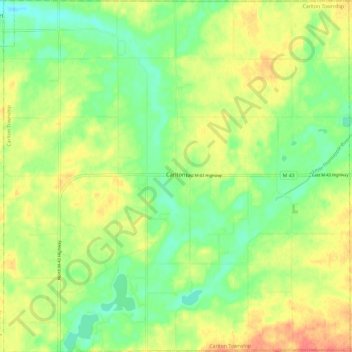
Name: Carlton Township topographic map, elevation, terrain.
Location: Carlton Township, Barry County, Michigan, United States (42.68250 -85.30959 42.76984 -85.19241)
Average elevation: 255 m
Minimum elevation: 231 m
Maximum elevation: 284 m
Other topographic maps
Click on a map to view its topography, its elevation and its terrain.
Baltimore Township
United States > Michigan > Barry County
Baltimore Township, Barry County, Michigan, United States
Average elevation: 280 m
Deep Lake
United States > Michigan > Barry County
Deep Lake, Yankee Springs Township, Barry County, Michigan, United States
Average elevation: 269 m
Orr Lake
United States > Michigan > Barry County
Orr Lake, Orangeville Township, Barry County, Michigan, United States
Average elevation: 286 m
Gun Lake
United States > Michigan > Barry County
Gun Lake, Yankee Springs Township, Barry County, Michigan, United States
Average elevation: 234 m